Ukraine
The Black Sea GOOS program in Ukraine joins efforts of institutions from the National Academy of Sciences,
Hydrometeorological, Ecological and Fisheries Services.
Basic observations
Elements of observation and data management systems, climatic analyses and development of near-operational products are
being carried out in the frame of programs funded by Ministry of Education and Science,
the National Academy of Sciences and the State Hydrometeorlogical Service. A significant part of the system development is done with support of the Science and Technology Center in
the Ukraine (STCU), the EU programs INTAS and INCO-COPERNICUS, the USA program Civilian and Research Development Foundation (CRDF) and other international collaboration.
Standard hydrographyc/hydrochemical observations
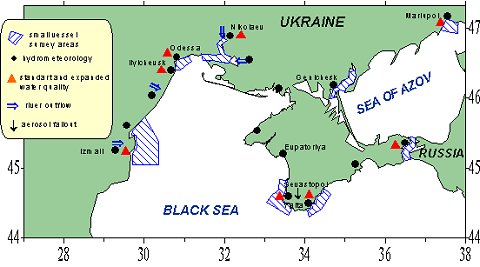
The Ukrainian national system of marine coastal observations consists of 36 hydrometeorological stations of different classes situated on
the Ukrainian shores of the Black Sea, the Sea of Azov, in the marine straits and mouths of rivers regions
(as show in Fig. 1). Observed variables are as follows: routine meteorology, river run-off, sea level, water temperature, salinity, waves and ice conditions, marine chemistry and pollutants.
List of Ukrainian shore hydrometeorological stations
|
Alushta |
Mysovoye |
Feodosiya |
|
Belgorod-Dnestrovsky |
Nikolayev |
Kherson |
|
Berdyansk |
Odessa |
Khersonessky mayak |
|
Genichesk |
Opasnoye |
Khorly |
|
Geroyskoye |
Ochakov |
Tsaregradskoye girlo |
|
Izmail |
Paromnaya pereprava |
Chernomorskoye |
|
Evpatoriya |
Parutino |
Chongarsky most |
|
Zavetnoye |
Primorskoye |
Port Yuzhny |
|
Ilyichevsk |
Sevastopol |
Yalta |
|
Kasperovka |
Skadovsk |
Stereguschiy |
|
Kertch |
Stanislav |
Strelkovoye |
|
Mariupol |
Ust-Dunaysk |
Reny |
Seven stations have small research vessels implementing the regular hydrometeorological and chemical observations in coastal waters within the distance from 1-2 to 5-10 miles. Regular ship observations are executed in
following areas.
Southern seashore of Crimea, the port of Yalta. Oceanographic surveys on 30 stations in the
5-mile band of coastal waters between the town of Alushta and Alupka; A
10-mile “secular” section from the port of Yalta towards the south-east;
A “secular” roadstead station 1 mile from Yalta. R/v “Neptun”.
South-western coast of Crimea, port of Sevastopol. Oceanographic surveys
taken at 15-30 stations in the 5-mile coastal waters between the cape
of Lukull and cape
Sarytch; surveys of Sevastopol bight taken at 10-15 stations or the cross-sections
at 5-7 stations along the bight’s axis. R/v “Poriv”.
Region of the Danube river mouth, port of Izmail. Oceanographic surveys
at 50 stations in the 50-mile coastal waters from the Danube’s mouth to the island
of Zmeiny; A 20-mile “secular” section at 9 stations along the latitude 45°20’ N. R/v “Meridian”.
Dnieper-Bug estuary and marine coastal waters, the port of Nikolaev. Surveys in the
Dniper-Bug estuary at 25-30 stations and 3-9 stations within the marine coastal waters. R/v “Typhoon”.
Kertch Strait, village Opasnoye. Surveys of the Kertch Strait at 15-20 stations; “secular” section across the strait
at 8 stations; A “secular” roadstead station in the center of the strait. R/v “Burun”.
Northern seashore of the Taganrog Bay in the Sea of Azov, port of Mariupol. Surveys of coastal waters near Mariupol
at 15 stations; 8-miles “secular” section from the port of Mariupol towards the south-south-east
at 6 stations; “secular” roasted station in 1 mile of
Mariupol. R/v “Shkval”.
Western seashore of the Sea of Azov, city of Genichesk. Surveys of the Utliuk’s firth and lake Sivash
at 12 stations; “secular” roadstead station in the Tonkiy strait.
The coastal sea temperature, salinity, respective transparency (Secchi depth) and colour (in the standard scale) are measured,
standard meteorological parameters are measured with small vessels. Occasionally, marine current speed and direction are registered. Distributions of oceanographic properties with depth are taken by means of Nansen’s bottle series or
CTD-probes (the lasts are used occasionally, during joint works with research institutes). Water samples are taken for chemical analyses and
pollutant control. Oceanographic and meteorological observational data are processed using standard methods.
Figure 1. Marine observations network (main components) of the Ukrainian.
Hydrometeorological Service
Regular roadstead observations are executed every 10 days all the year round with intermissions under hard meteorological conditions.
Oceanographic and chemical surveys for a water quality control as well as “secular” sections are executed, basically, once per season (4 times per year).
The exception is at Yalta where such surveys and sections are executed every month. Intermissions
have occured because of insufficient funding.
Operational forecasting and information marine services
Operational marine services for the Black Sea are carried out by four forecasting units of National Hydrometeorological Service.
The Hydrometeorological Centre for the Black Sea and the Sea of Azov in Odessa is the main marine forecasting and methodological organization. It prepares and transmits one- and two-day weather and wave forecasts, storm and gale warnings for the Black Sea, short-term sea water temperature and ice forecasts for the north-western coast of the Black Sea and
the Kertch Strait, weather and wave forecasts for waterways in the Black Sea,
the Sea of Azov, the Mediterranean and the Red Sea. It provides ship navigation by recommended courses for the Atlantic and Indian oceans, forecasts and
gives real-time information for the ports of Odessa, Nikolayev and Yuzhny.
The Hydrometeorological Bureau of Ilyichevsk prepares one-day weather and wave forecasts, storm warnings for the Ilyichevsk area,
and forecasts for the ferry route Ilyichevsk - Varna.
The Danube Observatory in Izmail prepares weather forecasts and storm warnings for the Danube region of
the Ukraine, including the ports of Reni, Izmail, Kiliya and Ust-Dunaysk.
The Hydrometeorological Bureau of Sevastopol prepares one-day weather and wave forecasts,
and storm warnings for the Sevastopol area, ports of Evpatoriya, Yalta,
and Feodosiya, offshore oil and gas platforms in the Karkinitskiy and Kalamitskiy Bays.
Shortcomings in the observational network functioning.
Development of the observational network.
To promote the quality of the marine observational network already operating, it is necessary to solve several financial and law problems:
Technical retrofitting of shore hydrometeorological stations and research vessels especially
Regular implementation of near-shore oceanographic surveys and "secular" sections. Three main sections from well developed in 60-80th system were connected to
the Crimea peninsula (Cape Chersonese –
Bosphorus, Yalta – Batumi, to the South of Cape Sarych) and can be provided, at least, once per season.
The development of an operational data exchange system via the Internet or
the Intranet with a clear agreement on data accessibility and appropriate computer equipment.
Solving the problem of carrying-out observations in economical zones or territorial waters of bordering states to implement
a full set of oceanographic stations.
Seven stations possess vessels, which conduct regular oceanographic and chemical observations in coastal areas up to 10 miles offshore. Regular coastal ship observations are carried out in
a few areas.
Survey of 30 casts within a 5-mile zone from the city of Alushta to the city of
Alupka, a 10-mile standard section of 5 casts SE-ward from Yalta and the standard station one mile off Yalta are carried out near the southern coast of the Crimea.
Surveys of 15-30 casts a within the 5-mile zone from cape Lukull to cape Sarych,
a survey of Sevastopol Bay (10-25 casts) or along the bay section of 5-7 casts are carried out near south-western coast of the Crimea.
The pollution monitoring within 10-miles of the coastal zone is performed near
the Danube mouth. Surveys of the Dnieper-Boug estuary of 25-30 casts and surveys in coastal waters 3-9 casts.
The list of measured variables during a survey includes temperature, salinity, color and transparency of seawater, standard meteorology, currents (occasionally), water samples for chemistry and pollution. Surveys and standard sections are sampled seasonally (four times per year). Information from the coastal network is collected and used for scientific analysis and end-user services.
Satellite altimeter sea level data set
The altimeter sea level data based on ERS and TOPEX/POSEIDON (T/P) measurements are available for the Black Sea for 1992-2000.
(The work is a result from the collaboration between NASA GSFC and the MHI NANU
within the framework of the STCU project N 1547.)
The altimeter data was pre-processed by the NASA Ocean Altimeter Pathfinder Project at Goddard Space Flight Center with all the necessary corrections for transmission effects and the geoid. Pre-processing of altimeter data also included filtration of errors according to the two-sigma criterion. In
addition, the points located at a distance of less than 30 km from the coast were excluded to eliminate
discrepancies caused by the influence of storm surges, shallow water tides, and coastal trapped waves.
Theoretical analysis shows that the response of the sea level to the low-frequency variability of the water budget should be spatially uniform and almost instantaneous (order of a day) as the size of the Black Sea is smaller than the barotropic deformation radius. Therefore the spatially averaged altimeter data describes variation of the basin volume.
Numerical eddy-resolving model with remote sensing altimeters assimilation operates now for the Black Sea.
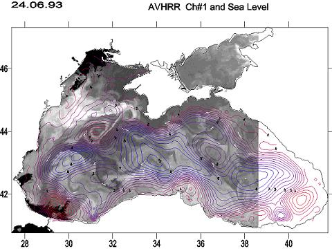
An example of the dynamical sea level, which is the stream function of the surface geostrophic currents, hindcast for June, 24, 1993 is presented on Fig.
2. Isolines of the sea level are overlapped on the AVHRR image to show how surface
current induces heterogeneities of the particular matter distribution in the upper sea layer.
Figure 2. Isolines of the sea level are overlapped on the AVHRR image. The formation of the
long filament by surface currents is well seen on the upper
left part of the image.
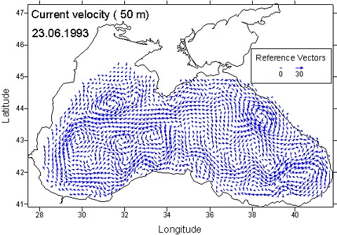
Example of mesoscale sea surface currents after altimeter assimilation is presented on
Fig.3. The set of marginal anticyclones is clearly defined in this
picture.
Figure 3. Sea surface currents after altimeter assimilation.
The spatial uniformity of sea level oscillations induced by the volume variation
allow us to retrieve the dynamic sea level from altimeter data. Altimeter derived dynamic sea level is validated against the dynamic topography calculated from the hydrography of the CoMSBlack program.
The statistics of the comparison between altimeter and hydrography sea level shows that the rms error of
the altimeter sea level is equal to 3.04 cm. Topography for the altimeter and hydrography sea levels corresponding to the periods of CoMSBlack surveys is in good qualitative agreement.
|