Georgia
The Georgian Coastal Zone encompasses part of the Black Sea coast 326 km in length from the mouth of the River Psou (state border with the Russian Federation) to Kelenderi Cape (border with Turkey). Its sea boundary passes mostly along the 130 -m isobath and deflects to the sea only in the mouths of large rivers. Land border represents an imaginative limit up to which the sea water action is spreading during high activity. The area of this zone is about 2600 km-, from which
the sea part makes up 2200 km (85 %). The Average width of this zone is about 8 km and
the largest width reaches 25 km
(Gudauta sand bank).
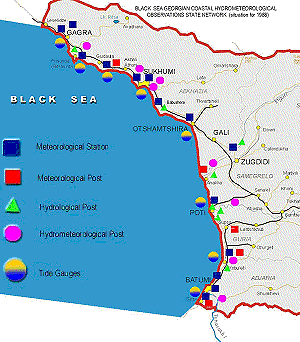
In the coastal zone of Georgia there were 32 meteorological
stations , 6 tide gauges, ship observations at 35 hydrographic stations and 45 observation stations in regards to marine pollution
monitoring until the early 1990s (Figure 1). Collection, systematization and processing of data from this network was carried out in the Hydrometeorological Observatory of
Batumi, which also had a coastal research ship, a hydrochemical laboratory and communication means. This observatory was responsible for informing the Georgian Marine Shipping Company, navigation ships and other users of operational hydrometeorological information and marine forecasts. From this Observatory the systematized results of the observations were sent to the Information Centers of the former USSR.
The oceanographic observations of Georgian Coastal Hydrometeorological Network
and marine synoptic products are stored at the Informational Centers of Obninsk and Sevastopol.
Since the 1990s the socioeconomic and political issues in Georgia have had
a negative
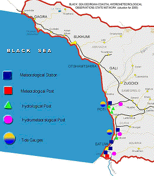
effect on the hydrometeorological observation network. Presently only 5 meteorological stations and 3 tide gauges are
functioning (Figure 2). The ship observations have almost stopped and the hydrochemical measurements occur episodically.
The pipeline from Baku-Supsa is in operation. Since the seaport in Supsa
has not been built yet, the transportation of oil is carried out by means of the marine oil buoy and tankers. At the mouth of the river Khobi in
Kulevi, a terminal and seaport is being constructed in connection with the reestablishment of the historical "Silk Route" in the frames of the EU project Transport Corridor Europe-Caucasus-Asia
(TRACECA). Ferry boat lines from Batumi to Ilichevsk and Poti to Ilichevsk, and Varna are already in operation and marine navigation is increasing.
On the coast of Ureki-Shekvetili, a health resort complex is under construction.
The safety of transportation along the TRACECA route is determined by the specialized hydrometeorological operational information provided, since it affects the effective functioning, the security of haulage and the prevention of losses resulting from transportation delays due to unfavorable weather and marine conditions.
The first stage of the Georgian Black Sea GOOS' network will include the meteorological stations of Batumi, Kobuleti, Poti, Supsa and Kulevi and their tide gauges.
In the future the Georgian GOOS' observation network will include the hydrometeorological stations of
Abkhazeti: Sokhumi, Bichvinta and Gagra.
Figure 1. Black Sea Georgian Coastal Hydrometeorological Observation Network (situation for 1988)
Figure 2. Black Sea Coastal Hydrometeorological Observation Network (situation for 2000)
|